Overview of Alameda Creek Watershed
“Alameda Creek is a sparkling stream which rises in the mountains and dances lightly along its rocky bed, singing softly to the hills and trees that line its course, cheerily greeting the little tributaries that join it at the mouths of deep ravines, now and then taking a wild plunge over a ledge of rocks only to recover its accustomed dignity the next moment, and at length to spread out, clear and placid, upon the breast of the valley.”
—from Picturesque California, edited by John Muir, 1888
Alameda Creek is the third largest tributary to San Francisco Bay (after the Sacramento and San Joaquin rivers). The Alameda Creek watershed is the geographic area drained by Alameda Creek and its tributaries, encompassing more than 680 square miles of the East Bay. The watershed ranges from streams draining the south slopes of Mount Diablo in the north, most creeks from Mount Hamilton in the south, and arroyos as far east as Altamont Pass.
The main stem of Alameda Creek flows for forty miles, originating in the hills northeast of Mount Hamilton. Upper Alameda Creek descends through remote wildlands and ranches, Sunol and Ohlone Regional Wilderness Preserves, and San Francisco watershed lands down through the Sunol Valley in the southern portion of the watershed. The northern watershed includes the rapidly urbanizing towns of Livermore, Pleasanton, Dublin and San Ramon in the Livermore Valley, along the Arroyo Mocho and Arroyo de la Laguna tributaries. The confluence of Arroyo de la Laguna with Alameda Creek is near the hamlet of Sunol, where Alameda Creek begins its descent through Niles Canyon. The Stonybrook Creek tributary joins Alameda Creek in Niles Canyon. The lower region of the watershed includes the urbanized Tri-City area of Fremont, Union City and Newark on the San Francisco Bay Plain. Lower Alameda Creek is now constrained in a flood control channel, with its waters finally reaching San Francisco Bay just north of Coyote Hills.
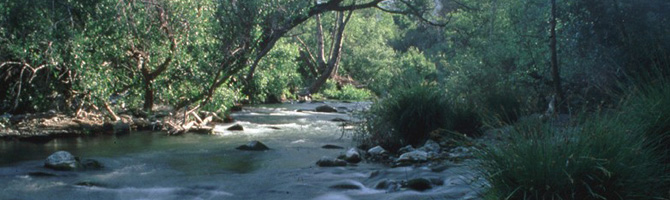
Along its course, Alameda Creek provides wildlife habitat, water supply, a conduit for flood waters, opportunities for recreation, and a host of aesthetic and environmental values. The creek and three major reservoirs in the watershed are used as water supply by the San Francisco Public Utilities Commission, Alameda County Water District and Zone 7 Water Agency. Within the watershed can be found the highest peaks (Mount Isabel and Mount Hamilton) and tallest waterfall (Murietta Falls) in the East Bay, over a dozen regional parks, and notable natural landmarks such as the cascades at Little Yosemite and the wildflower-strewn grasslands and oak savannahs of Sunol Preserve.
Although Alameda Creek is subject to periodic drought and many stream reaches and tributaries have naturally intermittent flow, migratory fish such as steelhead trout, coho salmon and chinook salmon once swam upstream to spawn in cold-water graveled reaches of the creek and its tributaries. Anadromous fish were extirpated by the early 1960s due to the impacts of dams, in-stream barriers, water diversions, habitat destruction, channelization projects, pollution and urban development. Despite extensive urbanization, flood control projects and major dams, Alameda Creek still supports a diverse assemblage of the native stream fishes of the San Francisco Bay region, with at least a dozen native fish species documented in recent years.
After an absence of half a century, ocean-run steelhead trout will soon be able to return to Alameda Creek to mingle with remnant rainbow trout populations. Completion of a series of dam removal and fish passage projects, along with improved stream flows for cold-water fish and planned habitat restoration, will improve and restore habitat conditions for migratory fish. Steelhead trout and chinook salmon will soon be able to access up to twenty miles of spawning and rearing habitat in Alameda Creek and its tributaries.